Navionics+ Marine Charts
Gallery
Attributes
Distributor offers
| Seller | SKU | MOQ | In stock | Multiple | Prices |
|---|---|---|---|---|---|
| 1033072 | 1 | 8 In Stock | 1 | 1 @ $199.99 | |
| westmarine.com | 20490561 | 1 | 1 | 1 @ $199.99 | |
 cemarine.com cemarine.com | 92605 | 1 | -2 | 1 | 1 @ $160.99 |
 delawarepaddlesports.com delawarepaddlesports.com | 010-C1366-30 | 1 | -2 | 1 | 1 @ $185.99 |
 Zoro Zoro | G506006534 | 1 | 1 | 1 @ $250.90 | |
 ritelinemarine.com ritelinemarine.com | 92605 | 1 | 48 | 1 | 1 @ $148.99 |
| NAI-010-C1366-30 | 1 | 15 | 1 | 1 @ $199.99 | |
| 010-C1366-30 | 1 | 11 | 1 | 1 @ $166.45 | |
| CWR-92605 | 1 | -2 | 1 | 1 @ $187.95 | |
| CWR-92605 | 1 | 24 | 1 | ||
| 6118062 | 1 | 27 | 1 | 1 @ $180.35 | |
| 1381-0600-YMLNCM9JAW | 1 | -2 | 1 | 1 @ $289.99 | |
 wateryachtsolutions.com wateryachtsolutions.com | NVN010C136630 | 1 | 13 | 1 | 1 @ $199.99 |
| 010-C1366-30 | 1 | 11 | 1 | 1 @ $169.83 |
Related on Amazon
As an Amazon Associate, we earn from qualifying purchases. (paid link) CERTAIN CONTENT THAT APPEARS ON THIS SITE COMES FROM AMAZON. THIS CONTENT IS PROVIDED 'AS IS' AND IS SUBJECT TO CHANGE OR REMOVAL AT ANY TIME.

Navionics 010-C1366-30+ Naus001l U.s. & Coastal Canada
Brand: Navionics
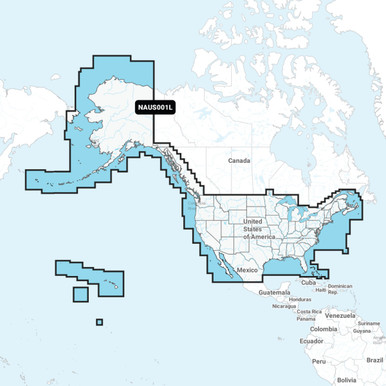
<p> NAUS001L U.S. & Coastal Canada - MicroSD Card < / p><p>Detailed coverage of the entire U.S. coasts, lakes, rivers, and inland waterways, plus Alaska and Hawaii. Canada coverage of coastal British Columbia, the Great Lakes, the St. Lawrence Seaway, New Brunswick, and Nova Scotia. Coverage includes Bermuda, the Bahamas, Baja California, the Gulf of California, Johnston Atoll, and Palmyra Atoll / Kingman Reef.< / p><p>Get the world’s No. 1 choice in marine mapping — with the best, most up-to-date Navionics®+ cartography on your compatible chartplotter. For offshore or inland waters, this all-in-one solution offers detail-rich integrated mapping of coastal waters, lakes, rivers, and more. Get SonarChart™ 1’ (0.5 meters) HD bathymetry maps, advanced features such as dock-to-dock route guidance technology (depending on chartplotter model), live mapping, and Plotter Sync to provide wireless access to daily updates. The Navionics® Chart Installer software also ensures the freshest chart data every time out. Navionics route guidance solutions give you a suggested dock-to-dock path to follow through channels, inlets, marina entrances, and more. (Route guidance is for planning purposes only and does not replace safe navigation operations.) Multiple shading options aid in shallow water navigation and make it easy to highlight a target depth range for the best fishing spots. < / p><p> Features: < / p><br>Integrated Garmin and Navionics® content provides exceptional coverage, clarity, and detail in a familiar look and feel <br>Easy access to daily chart updates is available via the Navionics® Chart Installer software or wirelessly via the Plotter Sync feature with the Navionics Boating app (The Plotter Sync feature requires the use of the Navionics Boating app on your compatible smart device with an active subscription of the same area.) <br>Navionics® advanced dock-to dock route guidance technology uses your boat settings, ...
Details
- Navionics chart card for marine navigation.
- Covers the U.S. and coastal areas of Canada.
- Provides detailed information on waterways, navigational aids, and points of interest.
- Compatible with Navionics chartplotter systems.
- Ideal for boaters and sailors navigating these regions.
Listing
| Binding | Misc. |
|---|---|
| Product group | Sports |
| Product type | SPORTING_GOODS |
| Part number | 010-C1366-30 |
| Items per pack | 1 |
| Label | Navionics |
| Manufacturer | Navionics |
Analytics
| Case Qty | 1 units |
|---|
Navionics+ NAUS001L - U.S. & Coastal Canada
Brand: Navionics
Navionics NAUS001L U S Coastal Canada
Analytics
| Case Qty | 1 units |
|---|