Access to this page has been denied.
Attributes
Distributor offers
| Seller | SKU | MOQ | In stock | Multiple | Prices |
|---|---|---|---|---|---|
| westmarine.com | 20490603 | 1 | 1 | ||
 cemarine.com cemarine.com | 92609 | 1 | -2 | 1 | 1 @ $146.99 |
 delawarepaddlesports.com delawarepaddlesports.com | 010-C1370-30 | 1 | -2 | 1 | 1 @ $149.99 |
 ritelinemarine.com ritelinemarine.com | 92609 | 1 | 35 | 1 | 1 @ $115.99 |
| NAI-010-C1370-30 | 1 | 92 | 1 | 1 @ $149.61 | |
 Zoro Zoro | G407893455 | 1 | -2 | 1 | 1 @ $239.00 |
| 010-C1370-30 | 1 | 5 | 1 | 1 @ $125.22 | |
| CWR-92609 | 1 | -2 | 1 | 1 @ $140.95 | |
| CWR-92609 | 1 | 1 | 1 @ $100.99 | ||
| 6118063 | 1 | 29 | 1 | 1 @ $135.25 | |
 wateryachtsolutions.com wateryachtsolutions.com | NVN010C137030 | 1 | 17 | 1 | 1 @ $149.99 |
| 010-C1370-30 | 1 | 13 | 1 | 1 @ $127.36 |
Related on Amazon
As an Amazon Associate, we earn from qualifying purchases. (paid link) CERTAIN CONTENT THAT APPEARS ON THIS SITE COMES FROM AMAZON. THIS CONTENT IS PROVIDED 'AS IS' AND IS SUBJECT TO CHANGE OR REMOVAL AT ANY TIME.

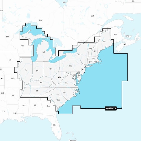
Navionics 010-C1370-30+ Naus007r U.s. East
Brand: Navionics
<p><strong>Navionics U.S East Regions(NAUS007R)- Marine and Lake Charts with Preloaded Micro SD Format(010-C1370-30)<br /><br /></strong>Detailed coverage of the lakes, rivers, and coasts of Connecticut, Delaware, Illinois, Indiana, Kentucky, Maine, Maryland, Massachusetts, Michigan, New Hampshire, New Jersey, New York, North Carolina, Ohio, Pennsylvania, Rhode Island, South Carolina, Tennessee, Vermont, Virginia, and West Virginia.<br /><br />Get the world’s No. 1 choice in marine mapping — with the best, most up-to-date Navionics+ cartography on your compatible chartplotter. For offshore or inland waters, this all-in-one solution offers detail-rich integrated mapping of coastal waters, lakes, rivers, and more. Get SonarChart 1’ (0.5 meters) HD bathymetry maps, advanced features such as dock-to-dock route guidance technology (depending on chartplotter model), live mapping, and Plotter Sync to provide wireless access to daily updates. The Navionics Chart Installer software also ensures the freshest chart data every time out. Navionics route guidance solutions give you a suggested dock-to-dock path to follow through channels, inlets, marina entrances, and more.<br /><br /><strong>FEATURE LIST:</strong></p><ul><li>U.S. East Marine Charts</li><li>Coastal Coverage</li><li>Dock-to-Dock Route Guidance Technology</li><li>Plotter Sync</li><li>Integrated Garmin & Navionics Data</li><li>Multiple Shading Options</li></ul><p> </p>
Details
- Integrated Garmin and Navionics content provides exceptional coverage, clarity, and detail in a familiar look and feel
- Easy access to daily chart updates is available via the Navionics Chart Installer software or wirelessly via the Plotter Sync feature with the Navionics Boating app (The Plotter Sync feature requires the use of the Navionics Boating app on your compatible smart device with an active subscription of the same area.)
- Navionics advanced dock-to dock route guidance technology uses your boat settings, along with chart data and frequently traveled routes, to calculate a suggested path to follow (Route guidance is for planning purposes only and does not replace safe navigation operations.)
- For improved fishing and navigation, SonarChart HD bathymetry maps display up to 1’ (0.5 meter) contours, providing a more detailed depiction of bottom structure
- SonarChart Live mapping feature allows boaters to create new personal 1’ HD bathymetry maps that display in real time on the screens of their compatible plotters while navigating
Listing
| Binding | Electronics |
|---|---|
| Product group | GPS or Navigation System |
| Product type | GPS_OR_NAVIGATION_SYSTEM |
| Part number | 010-C1370-30 |
| Label | Navionics |
| Manufacturer | Navionics |
Analytics
| Case Qty | 1 units |
|---|

Navionics+ NAUS007R - U.S. East
Brand: Navionics
Details
- Navionics+ NAUS007R - U.S. East
Listing
| Binding | Misc. |
|---|---|
| Product group | Sports |
| Product type | SPORTING_GOODS |
| Part number | 010-C1370-30 |
| Items per pack | 1 |
| Label | Navionics |
| Manufacturer | Navionics |
Analytics
| Case Qty | 1 units |
|---|