NAVIONICS MSD/HMPT-S6 hotmaps platinum south
Gallery
Attributes
Distributor offers
| Seller | SKU | MOQ | In stock | Multiple | Prices |
|---|---|---|---|---|---|
| SavingLots | MSD/HMPT-S6 | 1 | 8 | 1 | 1 @ $184.50 |
| westmarine.com | 11094265 | 1 | 1 | ||
 iboats.com iboats.com | IB00218685 | 1 | -2 | 1 | 1 @ $201.99 |
| Defender | 261385MSD-S6 | 1 | 1 | ||
| boatersplus.com | EB-5026041 | 1 | 1 | ||
| delawarepaddlesports.com | MSD/HMPT-S6 | 1 | 1 | ||
| G601972864 | 1 | 1 | 1 @ $199.00 | ||
 Zoro Zoro | G103532221 | 1 | 1 | 1 @ $213.95 | |
 Zoro Zoro | G003715328 | 1 | 1 | 1 @ $265.69 | |
| marine.com | 11-37636 | 1 | 1 | ||
| NAVIONICS ELECTRONIC CHARTS-MSD/HMPT-S6 | 1 | -2 | 1 | 1 @ $164.51 | |
| MSD/HMPT-S6 | 1 | -2 | 1 | 1 @ $359.70 | |
 homeessentialsdirect.com homeessentialsdirect.com | MSD/HMPT-S6 | 1 | 1 | 1 @ $146.90 | |
 socalpowersports.com socalpowersports.com | MSD/HMPT-S6 | 1 | 1 | 1 @ $199.00 | |
| 5930576 | 1 | 1 | 1 @ $179.46 |
Related on Amazon
As an Amazon Associate, we earn from qualifying purchases. (paid link) CERTAIN CONTENT THAT APPEARS ON THIS SITE COMES FROM AMAZON. THIS CONTENT IS PROVIDED 'AS IS' AND IS SUBJECT TO CHANGE OR REMOVAL AT ANY TIME.

Navionics HMPT-S6: HOTMAPS PLATINM South
Brand: Navionics
HotMaps Platinum provides the most content so you can take full advantage of your chartplotters functionality. Dynamic 3D View allows you to customize exaggeration of key features and adjust pitch to highlight subtle depth changes or better visualize your approach through shallow or narrow channels.<br> Available on the most popular lakes, satellite overlay imagery is extremely helpful for improving situational awareness and can help you find hidden features such as backwater channels that might hold fish.<br> Panoramic photos let you head into new marinas and recognize boat ramps with the confidence of a local, with a clear view of entrances, dock layouts, and more.<br> View detailed shorelines with marinas, docks and boat ramp locations. Increase your awareness of shallow waters and hazardous areas at any depth level including shoals, rocks, wrecks and more.<br> Fish smarter with up to 1 foot HD contours, you’ll find the best fishing spots: roadbeds, foundations, bridges, brush piles, culverts and creek channels.<br> Enhance your favorite areas. SonarChart becomes more precise every day with sonar logs contributed by the Navionics Community from all major plotter/sounder brands and mobile devices. And with SonarChart Live, you can use your plotter/sounder to create real-time personal HD bathymetry maps and upload sonar logs to Navionics.<br> Keep your GPS charts up to date. With around 2,000 edits per day, you’ll have the latest Nautical Chart, Sonar Chart and Community Edits enriched with information from official sources, our own surveys and research, and contributions from fellow boaters.<br> Additional features are available with select Raymarine models: Plotter Sync, Dock-to-dock Autorouting, SonarChart Live display on plotter and Advanced Map Options.<br> Nautical Chart and SonarChart are preloaded and ready to use. Download Community Edits along with daily updates for one year at navionics.com.<br>
Details
- Max detailed charts for cruising, fishing and sailing, plus 3D View, satellite overlay and panoramic photos all in one!
- Includes Nautical Chart, a robust chart resource trusted by boaters worldwide, SonarChart 1 ft HD bathymetry map that reflects ever-changing conditions, and Community Edits, valuable local information added by millions of Navionics Boating app users.
- Navionics offers the best-selling boating maps in the world. Get the most current charts - every day - with daily updates for one year!
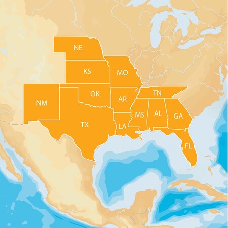
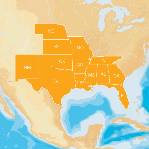
- Coverage area includes a growing list of more than 1,500 lakes in AL, AR, FL, GA, KS, LA, MO, MS, NE, NM and OK.
Listing
| Binding | Sports |
|---|---|
| Product group | Sports |
| Product type | SPORTING_GOODS |
| Model | MSD/HMPT-S6 |
| Part number | NAV-MSD/HMPT-S6 |
| Items per pack | 1 |
| Label | Navionics |
| Manufacturer | Navionics |
Analytics
| Case Qty | 1 units |
|---|
Hotmaps Plat South On M155Sd
Brand: Navionics
Catalog
| Feature | MSD/HMPT-S6 |
|---|---|
| Category | Books |
| MPN | MSD/HMPT-S6 |
| UPC | 821245125941 |
| EAN | 821245125941 |
| Product group | Book |
| Product type | MAPS |
| Manufacturer | Navionics |
Analytics
| Case Qty | 1 units |
|---|
Msd/hmpt-s6 - map, hotmaps platinum south
Catalog
| Category | Sports & Outdoors |
|---|---|
| MPN | MSD/HMPT-S6 |
| Manufacturer | NAVIONICS |
Analytics
| Case Qty | 1 units |
|---|

Navionics HotMaps Platinum Lake Maps South - microSD/SD
Brand: Navionics
Listing
| Binding | Personal Computers |
|---|---|
| Product group | Personal Computer |
| Product type | MONITOR |
| Model | MSD/HMPT-S6 |
| Part number | MSD/HMPT-S6 |
| Label | NAVIONICS |
| Manufacturer | NAVIONICS |
Analytics
| Case Qty | 1 units |
|---|

Navionics MSD/HMPT-S6 Navionics HotMaps Platinum Lake Maps South
Brand: Navionics
Listing
| Binding | Misc. |
|---|---|
| Product group | Sports |
| Product type | SPORTING_GOODS |
| Part number | MSD/HMPT-S6 |
Analytics
| Case Qty | 1 units |
|---|