| Brand name, Manufacturer name, Manufacturer, Brand, Label, Publisher, Studio | C-MAP |
|---|
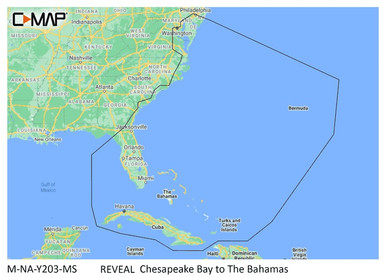
| KnownMan, Extra Product Name | C-MAP M-NA-Y203-MS Chesapeake Bay to Bahamas REVEAL |
|---|
| Weight | 0.15 0.0661386786 0.09038952742 |
|---|
| WeightUnit | lbs |
|---|
| keywords | C-MAP M-NA-Y203-MS Chesapeake Bay to Bahamas REVEAL? Coastal Chart |
|---|
| moq, multiple, tierMinQty1, Item_package_quantity, NumberOfItems, Number_of_items, PackageQuantity | 1 |
|---|
| MPN, SKU, Keyword, Model, ModelNumber, Model_number, Mpns, PartNumber, Part_number | M-NA-Y203-MS |
|---|
| qtyInStock | 0 |
|---|
| tierPrice1 | 249.90 |
|---|
| ASIN | B08YS1FWMH B0B1755Y3T |
|---|
| AdultProduct, Autographed, Batteries_included, Batteries_required, Has_color_screen, Memorabilia, TradeInEligible | False |
|---|
| Amount | 249.90 249.99 |
|---|
| Asin | B08YS1FWMH |
|---|
| Binding | Electronics Sports |
|---|
| Bullet_point | CUSTOM DEPTH SHADING: Set a clear safety depth, maintain a paper-like view or create your own custom shading. DYNAMIC RASTER CHARTS: Providing the traditional chart look and feel, coupled with easy access to all objects on the chart. FULL-FEATURED VECTOR CHARTS: Making navigation easy by giving you accurate, up-to-date vector chart detail derived from official Hydrographic Office information. HIGH-RES BATHY: Helps you identify shallow areas, drop-offs, ledges, holes or humps. Now includes compiled and quality-controlled Genesis detail as part of singular HRB layer. SHADED RELIEF: Bring the world around you to life, with 3D rendered land and underwater elevation – including areas of Ultra-High-Res Bathymetric imagery – a game-changer for anglers and divers. |
|---|
| ClassificationId | 551462 |
|---|
| Color | Black |
|---|
| Currency, CurrencyCode | USD |
|---|
| DisplayName | Marine GPS Chartplotters |
|---|
| Height | 0.2362204722 0.24 0.2799999997144 14.6 1613 300 312 313 360 45 47 54 800 |
|---|
| Human_interface_input | touch_screen |
|---|
| Identifier | 9420064118922 |
|---|
| IdentifierType | EAN |
|---|
| Included_components | C-MAP Chart microSD Card |
|---|
| IsBrandQuery | True |
|---|
| ItemClassification | BASE_PRODUCT |
|---|
| ItemName, Item_name | C-MAP Reveal Coastal - Chesapeake Bay to The Bahamas, Map Card for Marine GPS Navigation |
|---|
| Item_package_weight | 0.03 |
|---|
| Item_type_keyword | boating-gps-units |
|---|
| Item_type_name | marine chart |
|---|
| Length | 0.6 5.7480314902 5.75 5.8299999940534 |
|---|
| Link | https://m.media-amazon.com/images/I/41sYX8gjyPL._SL75_.jpg https://m.media-amazon.com/images/I/41sYX8gjyPL.jpg https://m.media-amazon.com/images/I/51-DadmjWCL._SL75_.jpg https://m.media-amazon.com/images/I/51-DadmjWCL.jpg https://m.media-amazon.com/images/I/514DPQJYhXL._SL75_.jpg https://m.media-amazon.com/images/I/514DPQJYhXL.jpg https://m.media-amazon.com/images/I/51AhjiLapfL._SL75_.jpg https://m.media-amazon.com/images/I/51AhjiLapfL.jpg https://m.media-amazon.com/images/I/51TcJZAPPJL._SL75_.jpg https://m.media-amazon.com/images/I/51TcJZAPPJL.jpg https://m.media-amazon.com/images/I/51zEus5cLLL._SL75_.jpg https://m.media-amazon.com/images/I/51zEus5cLLL.jpg https://m.media-amazon.com/images/I/61aLQRbzbiL._SL75_.jpg https://m.media-amazon.com/images/I/61aLQRbzbiL.jpg https://m.media-amazon.com/images/I/716NBnyC12L.jpg https://m.media-amazon.com/images/I/71C5uD2WozL.jpg https://m.media-amazon.com/images/I/71eJYxVgXlL.jpg https://m.media-amazon.com/images/I/71u19uNwloL.jpg https://m.media-amazon.com/images/I/81FO17XtyJL.jpg https://www.amazon.com/gp/bestsellers/electronics https://www.amazon.com/gp/bestsellers/electronics/551462 |
|---|
| List_price | 249.9 |
|---|
| Map_type | Nautical |
|---|
| Model_name | REVEAL |
|---|
| Model_year | 2021 |
|---|
| Package_level | unit |
|---|
| ParentAsins | B0B1755Y3T |
|---|
| ProductCategoryId | 551462 ce_display_on_website |
|---|
| ProductGroup | GPS or Navigation System Sports Wireless |
|---|
| ProductType, ProductTypeName | GPS_OR_NAVIGATION_SYSTEM |
|---|
| Product_site_launch_date | 2021-03-12T15:50:38.971Z |
|---|
| Rank | 111081 111441 111594 113687 137 146 37 41 49 49350 51474 55 56 59034 59368 65098 67546 68685 70693 74 77 80 83 96944 |
|---|
| Sku | C-MAP M-NA-Y202-MS C-MAP M-NA-Y203 C-MAP M-NA-Y203-MS C-MAP M-NA-Y215-MS C-MAP NA-D941 C-MAP NA-D964 C-MAP NA-M025 C-MAP NA-M028 C-MAP NA-Y939 C-MAP SA-D500 DAYTON CMAP MARWINMPANY SP100FT MARWINMPANY T201ESFT |
|---|
| Sport_type | Fishing |
|---|
| StrippedMpns | MNAY203MS |
|---|
| Style | Chesapeake Bay to the Bahamas |
|---|
| Supplier_declared_dg_hz_regulation | not_applicable |
|---|
| Title | C-MAP Reveal Coastal - Chesapeake Bay to The Bahamas, Map Card for Marine GPS Navigation Electronics Marine GPS Units & Chartplotters |
|---|
| Type | VARIATION ean |
|---|
| URL | https://m.media-amazon.com/images/I/41sYX8gjyPL._SL75_.jpg |
|---|
| Unit | centimeters inches kilograms pounds |
|---|
| Units | inches pixels pounds |
|---|
| Variant | MAIN PT01 PT02 PT03 PT04 PT05 PT06 |
|---|
| Warranty, Warranty_description | 1 year manufacturer |
|---|
| WebsiteDisplayGroup | ce_display_on_website sports_display_on_website |
|---|
| WebsiteDisplayGroupName | Sports |
|---|
| Width | 10.5 1280 2240 4.13 4.1338582635 4.1699999957466 500 75 |
|---|