C-Map . NA-C510FPCARD
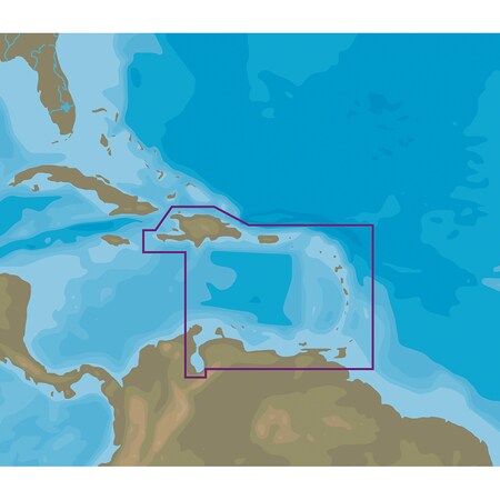
The C-MAP Nt+ NA-C510 Eastern Caribbean Sea - FP-Card Format is a digital charting system that provides accurate and up-to-date vector chart detail, including Depth Areas and Contours, Spot Soundings, NavAids, Light Sectors, Wrecks/Obstructions, Small Craft Facilities, and more. It also features Harbor & Approach Details, Tides, and C-Marina Port Database with detailed marina charts. This system is ideal for fishermen, sailors, and cruisers navigating the Eastern Caribbean Sea.
This premium domain name is available for purchase!
Gallery

Attributes
| Brand name, Manufacturer name | C-Map |
|---|---|
| Manufacturer | C-Map C-MAP |
| extendedLead | Ships: In 1 Business Day |
| moq, multiple, tierMinQty1, Item_package_quantity, PackageQuantity | 1 |
| MPN, Mpns, PartNumber, Part_number | NA-C510FPCARD |
| qtyInStock | -2 |
| SKU | IB00645305 |
| tierPrice1 | 296.99 |
| ASIN, Asin | B06WVD229W |
| AdultProduct, Autographed, Memorabilia, TradeInEligible | False |
| Amount | 249.00 |
| Aspect | exception proper_shipping_name transportation_regulatory_class |
| Binding | Electronics consumer_electronics |
| Brand, Label, Publisher, Studio | C-MAP |
| Bullet_point | C-MAP NT+ NA-C510 Eastern Caribbean Sea - FP-Card Format [NA-C510FPCARD] Expert Advice Available we are here to answer your questions. MSRP: $249.00, Mfg Part Number: [NA-C510FPCARD] Return shipping for damaged/defective items will be covered by the seller. |
| ClassificationId | 1000 |
| Compliance_type | on_product_combined_cancer_reproductive |
| Currency, CurrencyCode | USD |
| DisplayName | Subjects |
| Hazmat | 3 AU_NoAir BR_NoAir CA_NoAir CN_NoAir DE_NoAir ES_NoAir FR_NoAir GB_NoAir IN_NoAir IT_NoAir JP_NoAir MX_NoAir SG_NoAir US_NoAir auto-grounding |
| Height | 1.0 1.00 1000 500 75 |
| IsAdultProduct | false |
| ItemClassification | BASE_PRODUCT |
| ItemName, Item_name, Title | C-MAP Nt+ Na-C510 Fp Format Eastern Caribbean Sea - NA-C510FPCARD |
| Item_package_weight, Item_weight | 0.3 |
| Item_type_keyword | wall-maps |
| Keyword | C510 |
| Length | 10.0 10.00 |
| Link | https://m.media-amazon.com/images/I/51QCeAse9TL._SL75_.jpg https://m.media-amazon.com/images/I/51QCeAse9TL.jpg https://m.media-amazon.com/images/I/61tE0fPENrL.jpg |
| List_price | 249.0 |
| ProductGroup, WebsiteDisplayGroupName | Book |
| ProductType, ProductTypeName | MAPS |
| Product_description | NT+ NA-C510 Eastern Caribbean Sea - FP-Card FormatCOVERAGE AREA:Eastern Caribbean SeaCARD FORMAT:FP-CardC-MAP NT+ cartography helped launch a digital charting revolution years ago, and it is still as useful and reliable as ever. For fishermen, sailors and cruisers who continue to depend on C-MAP NT+, we provide updates twice annually to ensure that navigators benefit from all the latest Coast Guard Notice to Mariner (NTM) changes and other important chart data updates.Features:Full Featured Vector Charts C-MAP NT+ provides boaters with the accurate, up-to-date vector chart detail including Depth Areas and Contours, Spot Soundings, NavAids, Light Sectors, Wrecks/Obstructions, Small Craft Facilities and more.Harbor & Approach Details The detail and information available with C-MAP NT+ charts lets boaters approach any harbor and inlet with confidence - the perfect conclusion to a long voyage, sailing adventure or exciting day of bluewater fishing.Tides C-MAP NT+ Tides feature presents the time, water level and direction of tides with Tide Level graphs. This information is vital for navigation and fishing.C-Marina Port Database C-Marina Port database and detailed marina charts in C-MAP NT+ provides useful, categorized information for cruisers, fishermen and sailors - including Port Layout and Facilities, Operating Hours, Accessibility, phone/Email Contact Info and more.Global CoverageRich chart detail and available data to aid in safe navigationPort & Tide InformationFrequently updated chart dataEasy on-screen queries of chart objects for greater situational awarenessCompatible with many brands and models of chartplotters on the waterCompatible with PC Planner Specifications:Card Format: FP CardBox D |
| Product_site_launch_date | 2017-02-16T06:25:23.391Z |
| StrippedMpns | NAC510FPCARD |
| URL | https://m.media-amazon.com/images/I/51QCeAse9TL._SL75_.jpg |
| Unit | inches pounds |
| Units | inches pixels pounds |
| Variant | MAIN |
| WebsiteDisplayGroup | book_display_on_website |
| Weight | 0.3 0.30 |
| Width | 1000 500 6.0 6.00 75 |
Distributor offers
| Seller | SKU | MOQ | In stock | Multiple | Prices |
|---|---|---|---|---|---|
| iboats.com | IB00645305 | 1 | -2 | 1 | 1 @ $296.99 |
 Zoro | G4639416 | 1 | 1 | 1 @ $277.05 | |
 unbeatablesale.com | CW67338 | 1 | Out Of Stock | 1 | 1 @ $265.75 |
| marine.com | 11-64861 | 1 | 1 | ||
| 5922544 | 1 | 1 | 1 @ $244.86 |
Related on Amazon
As an Amazon Associate, we earn from qualifying purchases. (paid link) CERTAIN CONTENT THAT APPEARS ON THIS SITE COMES FROM AMAZON. THIS CONTENT IS PROVIDED 'AS IS' AND IS SUBJECT TO CHANGE OR REMOVAL AT ANY TIME.

C-MAP Nt+ Na-C510 Fp Format Eastern Caribbean Sea - NA-C510FPCARD
Brand: C-MAP
NT+ NA-C510 Eastern Caribbean Sea - FP-Card FormatCOVERAGE AREA:Eastern Caribbean SeaCARD FORMAT:FP-CardC-MAP NT+ cartography helped launch a digital charting revolution years ago, and it is still as useful and reliable as ever. For fishermen, sailors and cruisers who continue to depend on C-MAP NT+, we provide updates twice annually to ensure that navigators benefit from all the latest Coast Guard Notice to Mariner (NTM) changes and other important chart data updates.Features:Full Featured Vector Charts C-MAP NT+ provides boaters with the accurate, up-to-date vector chart detail including Depth Areas and Contours, Spot Soundings, NavAids, Light Sectors, Wrecks/Obstructions, Small Craft Facilities and more.Harbor & Approach Details The detail and information available with C-MAP NT+ charts lets boaters approach any harbor and inlet with confidence - the perfect conclusion to a long voyage, sailing adventure or exciting day of bluewater fishing.Tides C-MAP NT+ Tides feature presents the time, water level and direction of tides with Tide Level graphs. This information is vital for navigation and fishing.C-Marina Port Database C-Marina Port database and detailed marina charts in C-MAP NT+ provides useful, categorized information for cruisers, fishermen and sailors - including Port Layout and Facilities, Operating Hours, Accessibility, phone/Email Contact Info and more.Global CoverageRich chart detail and available data to aid in safe navigationPort & Tide InformationFrequently updated chart dataEasy on-screen queries of chart objects for greater situational awarenessCompatible with many brands and models of chartplotters on the waterCompatible with PC Planner Specifications:Card Format: FP CardBox D
Details
- Expert Advice Available we are here to answer your questions.
- C-MAP NT+ NA-C510 Eastern Caribbean Sea - FP-Card Format [NA-C510FPCARD]
- MSRP: $249.00, Mfg Part Number: [NA-C510FPCARD]
- Return shipping for damaged/defective items will be covered by the seller.
Listing
| Binding | Electronics |
|---|---|
| Product group | Book |
| Product type | MAPS |
| Part number | NA-C510FPCARD |
| Label | C-MAP |
| Manufacturer | C-MAP |